15
Hebron's Cave of the Patriarchs Will Be Packed This Weekend. Photographs from the Cave 100 Years Ago
In synagogues around the world this Sabbath, congregations will read the Torah portion describing Sarah's death and burial. Abraham purchased the Mearat HaMachpela [literally the "double cave" -- so named either because it had two chambers or it would eventually contain pairs of husbands and their wives].
Cave of the Patriarchs, Hebron (circa 1900)
Genesis 23: And these were the days of Sarah, 127 years. Sarah died in Kiryat-Arba which is Hebron....Abraham spoke to the Sons of Heth: grant me legal possession of land for a burial site... for its price in full ... 400 shekels of silver.... Thus it was established, the field and the cave that was in it, for Abraham as legally possessed for a burial site from the Sons of Heth."
In Israel, thousands of Jews will converge on Hebron and pray in the Cave of the Patriarchs and Matriarchs during the Sabbath.
"Inner entrance to
Machpelah showing mammoth
stones in Herodian wall"
The massive building surrounding the gravesite was built by King Herod two thousand years ago. The actual graves are located in subterranean caverns beneath. Their locations are marked above ground by cenotaphs -- empty tombs that serve as monuments.
In the 11th and 12th century Jewish travelers documented visiting the caves. One of them, Binyamin of Tudela, described "two empty caves, and in the third ... six tombs, on which the names of the three Patriarchs and their wives are inscribed in Hebrew characters. The cave is filled with barrels containing bones of people, which are taken there as to a sacred place." 
Cenotaph above the Tomb of Sarah
(circa 1900)

Tomb of Abraham
The great Jewish scholar Maimonides visited the tombs in 1116 and declared it a personal holy day.From the 14th century, however, Jews were not permitted to pray at the shrine. The Mamluks (an Islamic army of slave soldiers) forbade Jews from visiting the site other than standing on stairs outside. The practice continued until 1948 when all Jews were banned from the Jordanian-occupied West Bank.
"Cenotaph of Isaac
showing distinctive
features of
Crusader Church"
When Israel captured the area in 1967 Jews were allowed to visit the Cave of the Patriarchs, but Israel allowed the Islamic Waqf authorities to maintain control of large portions of the site.Hebron today, where school boys recently celebrated
completion of the book of Genesis
Many Jewish families in Israel celebrate weddings, bar mitzvas and circumcisions at the shrine.
It's easy to be confused by the American Colony collection's pictures of Metulla, Israel's northern-most town. One caption calls it a British post; another labels it a French post. Nor are the listed dates of the pictures much help; they were taken sometime between 1920 and 1933.
Northern-most town
(Wikipedia,Ynhockey)
Actually, both versions may be correct.
Metulla was established as a Jewish settlement in 1896 on land purchased by Baron de Rothschild. But despite the Turkish control of the area and then the French sovereignty, the lawlessness of the region forced the residents of Metulla to occasionally flee their homes.
After World War I, the British and French divided the spoils of the Middle East in 1920, with Britain given the mandate over Palestine and Mesopotamia and France given the mandate for Syria and Lebanon. They drafted a "Convention on certain points connected with the mandates for Syria and the Lebanon, Palestine and Mesopotamia, signed at Paris, December 23, 1920."
"Metulla. British frontier post." Note the British
flag on the building.
They even wrote "the frontier will be drawn westwards as far as Metullah, which will remain in [British controlled] Palestinian territory."But the exact boundaries were still not defined and agreed upon until 1923. The residents of Metulla actually voted in French-led elections in Lebanon in the interim. They looked to the French to protect them from marauding Bedouins and Druse. Only in the next year were new boundaries finally demarcated, placing the border between British and French controlled regions some 30 meters north of Metulla. Britain established a military outpost in the town.It is very possible that the American Colony photographers were filming the changing soveignty over Metulla.

"Hasbany Valley and Hermon looking
down from French Metulla post"
Click on the photos to enlarge.
Click on the captions to see the originals.

Metulla today. Lebanon is beyond the town. (Wikipedia,
public domain)
Today, Metulla is a popular vacation town for Israelis and home to 2,000 residents. The town's Canada Centre is a massive winter sport facility, complete with an olympic-size skating rink where Israel's skating champions practice.
Situated on the Lebanese border and close to the Syrian border, Metulla over the years has been a target for the rockets and artillery bombardments from Hizbullah and Fatah.0
Add a comment

Israel Daily Picture (IDP) is publishing its 100th photo essay this week. After discovering the American Colony photo collection in the Library of Congress five months ago, we wondered if there are enough photographs and topics to sustain this blog.
The answer is clear: YES! There are hundreds of pictures left to be analyzed and puzzles left to be solved. Hundreds of pictures showing Jewish life in the Holy Land 100 years ago need to be publicized.
The Israel Daily Picture has now been reprinted in many newspapers, blogs and social media sites.
At this stage, the IDP is initiating a short-term development project so that we can continue publication, research, translation, and even publication of a book. We seek:
- Organizational Sponsors
- Publications interested in syndicating the IDP
- Patrons
- Subscribers (who voluntarily pay, the subscription is still free)
- Individuals interested in dedicating a daily picture
Interested parties contact Israel.dailypix@gmail.com0
Add a comment
The date: July 7, 1920
Guests at the High Commissioner's reception (1920)
The place: The Government House, Jerusalem
The Occasion: The High Commissioner's Reception
Those are the details we know from the photograph's caption. But what brought together these ultra-Orthodox rabbis, British officers, Arab dignitaries and Eliezer Ben-Yehuda, the founder of modern Hebrew, who appears to be standing behind the rabbis? [Both the men -- the one in the light suit and his partner with the hat -- look like the man on the stamp.] And what are all the men holding?
On June 30, just a week earlier, the first British High Commissioner, Herbert Samuel, arrived in Palestine. The British army captured all of Palestine in 1917-1918 and imposed military rule. Samuel invited the leaders of Jerusalem's society to hear and receive a proclamation marking the new civilian rule over Palestine.
Samuel's arrival by rowboat, Jaffa
Port, June 30, 1920
Samuel read the proclamation and presented a copy to all of his guests.
As for the identity of the rabbis, the man on the left has been identified as Rabbi Moshe Leib Bernstein, a wealthy Jerusalem businessman; second from the left is the venerated Rabbi Yosef Chaim Sonnenfeld, the chief rabbi of Jerusalem's ultra-Orthodox community; next, Rabbi Yerucham Diskin, the son of a revered rabbi who set up the Diskin Orphanage in 1881 (which still helps needy children); and Rabbi Baruch Reuven Jungreis of the ultra-Orthodox rabbinate.
Samuel reading his
proclamation again two
days later.
Rabbi Sonnenfeld joined other rabbis a year later to meet with Colonial Secretary Winston Churchill at Samuel's Government House. See the posting and video here describing the meeting. Also attending the meeting with Churchill was Emir Abdullah who would become King Abdullah of Jordan. Sonnenfeld, Bernstein and Jungreis met with Abdullah in Jordan in 1924.0
Add a comment
- A version of this posting first appeared on October 4

Tell Pioth on the Plain of Rephaim is actually
Talpiot in southern Jerusalem
This pastoral picture from the Library of Congress collection bears the date 1925 and the caption, "Jewish colony of Tell Pioth on the Plain of Rephaim."
Where's Tell Pioth?
It may take a few seconds for anyone who knows Jerusalem to realize that the picture is of the Talpiot neighborhood in southern Jerusalem. The "Plain of Rephaim" is the continuation of "Emek Refaim" Road in Jerusalem's German Colony.
Israel Daily Picture discovered another picture of Talpiot dating back to the same period as the Library of Congress picture in Stephanie Comfort's amazing Jewish Postcard Collection.
Postcard showing the new Jerusalem suburb "Talpioth"
(with permission of the Jewish Postcard Collection)
The land for Talpiot was purchased in 1911 from German Templers of the German Colony of Jerusalem. Standing on the land and looking northeast toward Jerusalem's Old City and the Tower of David, the Jewish founders saw themselves as guardians of the Holy City, specifically the "talpiyot (turrets)" as expressed in the Bible's Song of Songs, 4:4 "Thy neck is like the tower of David, built with turrets."
The Turkish army's parade ground was located on the "Rephaim Plain," according to the Library of Congress photo captions. With the Old City turrets and the Church of the Dormition in the background of this picture of the Turkish and German commanders reviewing their troops, it appears that this is the area where Talpiot was built.
Army parade ground. Is this the land
that would become Talpiot?
By 1924 the first 40 homes were built, but the community suffered from deadly Arab attacks in 1929 and again in 1936.
Among the early settlers in Talpiot was the writer S.Y. Agnon who wrote about the neighborhood in his book, The Fire and the Trees. "I stood among the small trees that surround gardens... and on the path that I love the small houses and the refreshing gardens..."
Trees, gardens and small houses such as those in the first picture.0
Add a comment
A shorter version of this essay first appeared in July 2011.
Rachel's Tomb/ Photo is an ink-based photolithograph (1890)
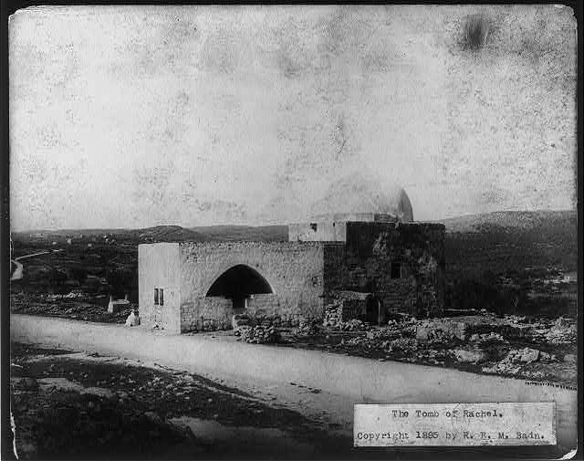
Tens of thousands of Jews -- mostly women -- are expected to visit Rachel's Tomb tonight and tomorrow. The burial site, located between Jerusalem and Bethlehem, has been venerated by Jews for centuries.
"And Rachel died, and was buried on the way to Ephrath, which is Bethlehem. And Jacob set a pillar upon her grave: that is the pillar of Rachel's grave unto this day." Genesis35:19-20
Tuesday, the 11th of Cheshvan in the Hebrew calendar, is traditionally observed as Rachel's yahrzeit -- anniversary of her death. Buried on the side of the road by her husband, Rachel, according to tradition, later wept as "her children" were exiled from the land of Israel. Rachel is considered a special figure for prayers and entreaties.
"30 men ('3 minyans') from a Jerusalem old age home praying for
the well-being of friends and donors and other brethren from the
House of Israel in the Diaspora next to the gravestone of Mother
Rachel of blessed memory." (Stephanie Comfort -- Jewish
Postcard Collection)
In 1622 the Ottoman governor of Jerusalem permitted Jews to build walls and a dome over the grave. [For historical background on Rachel's grave see Nadav Shragai.]
Click on the photos to enlarge.
Click on the captions to see the originals.
All photos are from the American Colony collection unless otherwise credited.

Visitors to Rachel's Tomb (circa 1910). Note the carriages in
the background and Jewish pilgrims under the tree (see
enlargement below). (Oregon State University collection)
For several hundred years a local Bedouin tribe, the Ta'amra, and local Arabs demanded protection money from Jews going to Rachel's grave. In the 18th and 19th century the Arabs built a cemetery around three sides of the shrine in the belief that the proximity of the deceased to the grave of a holy person -- even a Jew -- would bestow blessings on the deceased in the world to come. Muslims even prepared bodies for burial at Rachel's grave.
In the 1830s, Jews received a firman [decree] from Ottoman authorities recognizing the Jewish character of the site and ordering a stop to the abuse of Jews there. In 1841, Sir Moses Montefiore secured permission from the Ottoman authority to build an anteroom for Jewish worshippers. During the 1929 Muslim attacks on the Jews of Palestine, the Muslim religious council, the Waqf, demanded the site.

Jewish pilgrim
in picture aboveFor 19 years of Jordanian rule on the West Bank (1948-1967), Rachel's Tomb was off limits to Jews. After the 1967 war, Israel reclaimed control of the site. In 1996 and during the Palestinian intifada in 2000-2001 Rachel's Tomb was the target of numerous attacks. The Israeli army built walls to protect worshippers and their access to the site.
Rachel's Tomb 1895

Rachel's Tomb 1898

Aerial photograph of Rachel's Tomb (1931)

British (Scot) soldiers stopping Arab in
weapons search, Rachel's Tomb 1936In October 2010, UNESCO declared that the holy site was also the Bilal bin Rabah mosque and objected to Israeli "unilateral actions" at the shrine. Bilal bin Rabah was Mohammed's Ethiopian slave and muzzein who died and was buried in Damascus. The claim that the site was a mosque was first made in 1996.4
View comments
6
New Photos Added to the "Gates of Jerusalem" Essays Damascus, Golden, Lions Gates & a Preview of Jaffa Gate
Israel Daily Picture uncovered "new old" pictures of the gates of Jerusalem's Old City, dating back to the 1890s.
Jaffa Gate (circa 1890) -- a preview of a future feature. Before
the emperor of Germany arrived in 1898, the Turks razed the
shops, filled the moat to the right and built a road
so he could ride into the Old City in his carriage.
Incredibly, the pictures were produced in color in an early color process.
We also present a preview of a future feature on Jaffa Gate.
See previous photo essays on the Zion Gate, Damascus Gate, Golden Gate, Dung Gate and Lions Gate.

Lions Gate (1890)

Damascus Gate (circa 1890)

Golden Gate (1890) 1
View comments
3
The Balfour Declaration Was Issued 94 Years Ago In 1925 Balfour Arrived to See the Jewish State in Formation

Balfour's reception in Tel Aviv (April 1925) The government of Great Britain issued the Balfour Declaration 94 years ago this week, on November 2, 1917. The document in effect served as the birth certificate for a Jewish national home.British Foreign Secretary Arthur Balfour's declaration was in the form of a letter to a leader of the British Jewish community. It stated:His Majesty's government view with favour the establishment in Palestine of a national home for the Jewish people, and will use their best endeavours to facilitate the achievement of this object, it being clearly understood that nothing shall be done which may prejudice the civil and religious rights of existing non-Jewish communities in Palestine, or the rights and political status enjoyed by Jews in any other country.

Balfour speaking at the founding of Hebrew University.
Behind him sit Chaim Weizmann and Chief
Rabbi Avraham Kook
The British Army had just captured Be’er Sheva (October 31) after months of trying to break through the Ottoman army’s Gaza-Be’er Sheva defense line. The British goal was to push north and capture Jerusalem by Christmas.In April 1925, Lord Balfour arrived in Palestine to lay the cornerstone for Hebrew University on Mt. Scopus. He was received as a hero in Tel Aviv and Rishon LeZion.
Balfour about to lay the Hebrew
University cornerstone[Unfortunately, many of the pictures were already in stages of disintegration when they were digitalized by the Library of Congress. They are presented without cropping the damaged sections.]In the Arab community his visit was marked with black flags.

Balfour welcomed at the Rishon LeZion Jewish community

Black flags flying on Arab house 1
View comments
Looking through the 22,000 American Colony pictures in theLibrary of Congress collection, it's easy to conclude that many of the photos are miscaptioned -- if they're captioned at all. And those that are captioned often do not provide an accurate date or enough information to identify the subjects, time and place.
Jews or Christians? "Russian pilgrims to Jerusalem aboard
vessel in Beirut harbor" (1903)
That's an important mission of Israel Daily Picture -- to uncover as much information as possible about Jewish life and communities in Eretz Yisrael more than 100 years ago.
Presented here are two examples. The first, a 1903 picture of "Russian pilgrims to Jerusalem aboard vessel in Beirut harbor" and a second 1903 photo of "Peasant women near Joppa [Jaffa] Gate, Jerusalem."
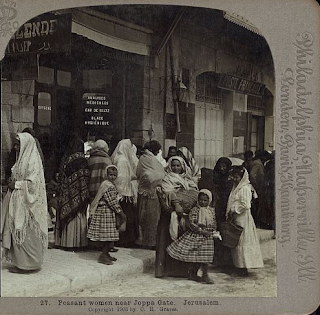
Are these women Jewish? "Peasant women near Joppa
Gate, Jerusalem" (1903)
The Library of Congress photo collection includes pictures of Russian Christian pilgrims visiting churches and baptism sites, such as the photo below of Russian pilgrims gathered at Jericho.Click on the photos to enlarge.Click on the captions to see the originals.
Note the headgear. All of the women in Jericho are wearing kerchiefs on their heads. But one of the passengers on the boat is not. Is she Jewish perhaps?Bearded men appear in both pictures, and "cossack"-style hats appear in both. But none of the men at Jericho are wearing the "hamburg"-style hats worn by some men on the ship, a style popular with Jewish men.
(See enlargement.)
Russian pilgrims (circa 1900)

A Jewish passenger? So the Russian Christians were sailing on a religious pilgrimage, but what of the Jews?
It is likely that they were part of the 35,000 Jews who left Russia after pogroms and anti-Jewish Czarist degrees. They were part of what is called the "First Aliya," a wave of Jewish immigration, dated 1880-1903.
Standing behind the "peasant" women:
Jewish men wearing fur "streimel" hats,
normally worn on the Sabbath
What can you make out of the picture of the peasants outside Jaffa Gate? The Library of Congress website allows for enlarging the photos, and who is in the background of the picture? Jewish men.
Women praying at the Kotel
The women are not wearing the black scarves worn by Muslim women, nor are their faces veiled. Indeed, compare the shawls and fabrics the "peasant" women are wearing with this picture of Jewish women praying at the Western Wall. In many cases the fabrics are identical.1
View comments
The wall of Jerusalem's Old City and many of the gates that we see today were built in 1540 during the days of the Ottoman Sultan, Suleiman the Magnificent. The Dung Gate is one of eight gates in the Old City Wall. , 
Dung Gate interior (circa 1900)

Dung Gate interior (circa
1940)
The original Dung Gate is mentioned in the book of Nehemiah 3:13. Close to the Temple Mount and facing the ancient City of David and the Shiloach spring, the original gate was probably well traversed. The gate is at the lowest point of the walls, and indeed it was probably used for removing refuse and possibly ashes from the Temple. A major drainage tunnel near the gate, more than 600 meters long and dating back at least to Herod's days, has recently been discovered and cleared and opened for tourists.
The Library of Congress collection includes one picture, incredibly captioned, "Ash heaps from the Temple sacrifices." The location of the photo is unclear but it does not appear to match the terrain below the Dung Gate.
"Ash heaps from the Temple
sacrifices" 1898

Dung Gate today. Note the small arch of
the original Ottoman gate on top of
the larger opening
The Ottoman-built gate was small and narrow, the upper arch of which is still visible above today's gate. In 1952, during Jordan's occupation of the Old City, the gate was widened to permit vehicles to enter. The opening was reinforced with cement posts. The gate was renovated by Israel after 1967 to match the Ottoman stone and design.
See previous photo essays on the Zion Gate, Damascus Gate, Golden Gate andLions Gate.2
View comments
27
The Kaiser Arrives, and the Rabbis Turn Out. How Jerusalem's Jews Greeted the German Emperor in 1898
The German Emperor's visit to Jerusalem on October 29, 1898 was a major historic event, reflecting the geopolitical competition between the German Empire, Russia, France and the British Empire. Emperor Wilhelm II and his wife were received with open arms by the Ottomans collapsing under the weight of centuries of corruption and still reeling from the aftermath of the costly Crimean War of the 1850s.
The welcome arch constructed by Jerusalem's Jews in honor
of the German Emperor Wilhelm II

Wilhelm II and Augusta Viktoria
Preparations were undertaken throughout Turkish-controlled Palestine: roads were paved, waterworks installed, electrical and telegraph lines laid, and sanitation measures -- seen today as basic -- were implemented. The Turks even breached the Old City walls near Jaffa Gate to construct a road for the Emperor's carriages.

Interior of the arch. Note the curtains hanging.
The visit was photographed extensively by the American Colony photographers. The popularity of the Emperor's pictures led to the establishment of the Colony's photographic enterprise and eventually the 22,000 pictures that were donated to the Library of Congress.
The Jews of Jerusalem were caught up in the excitement. Some of the Jews with ties to Europe were actually under the Emperor's protection. Others expected to benefit from the Emperor's largesse. And still others wanted the opportunity to recite a rarely said blessing upon seeing a king, according to David Yellin, a Jerusalem intellectual who described the visit in his diary.

Sephardi Chief Rabbi,
Yaakov Shaul Elissar
The Jewish community constructed a large and richly adorned welcome arch to receive the Emperor. The arch was located on Jaffa Road (near today's Clal Building) and bore the Hebrew and German title, "Welcome in the name of the Lord."
The Library of Congress collection offers viewers the ability to enlarge the photos, and once enlarged, the details under the arch are amazing. The chief rabbis of the time are easily recognizable, the arch is decorated along the top by Torah crowns, and it is clear that the arch is lined by the curtains from Torah arks, parochot.
Torah crowns and breastplate
on top of the arch

Chief Rabbi of Jerusalem,
Shmuel Salant
The enlargements show that one curtain came from the Istanbuli synagogue in the Old City, another was donated by the Bukhari community, and a third belonged to Avraham Shlomo Zalman Hatzoref, a student of the Gaon of Vilna and a builder of Jerusalem who arrived in Eretz Yisrael exactly 200 years ago. We can deduce that the thirdparochet came from the Hurva synagogue which Hatzoref helped to fund (actually arranged for the cancellation of the Ashkenazi community's large debt to local Arabs). For his efforts he was killed by the Arabs in 1851. Hatzoref is recognized by the State of Israel as the first victim of modern Arab terrorism.

Curtain from the Bukhari community 
Curtain from the
Istanbuli synagogue
The curtain lists several names besides Hatzoref. Their names are followed by the Hebrew initials Z'L -- of blessed memory. The fact that Hatzoref's name is not followed by Z'L suggests that the curtain was made prior to his death in 1851.

Hatzoref's parochet, suggesting it came
from the Hurva Synagogue
According to the New York Times account of the visit, two Torah scrolls were also on display in the Jewish arch, but they are not visible in the photographs.
Two individuals who should have been under the arch were not there. The first was Theodore Herzl who came to Palestine in order to meet with the Emperor and encourage him to express his support for a Jewish homeland to his Turkish allies. Yellin reported that Herzl was not invited by the local Jewish leadership, some of whom were opposed to the Zionist movement on religious grounds. Others were fearful that Herzl's message would anger the Turkish government. Herzl met the Emperor later at his compound on November 2 and at the Mikveh Yisrael agricultural school.
Photo montage of Herzl
and the Emperor at
Mikve Yisrael school
Also absent was the leader of the ultra-Orthodox Jewish community, Rabbi Chaim Yosef Zonnenfeld. According to some accounts, Zonnenfeld believed that the German nation was the embodiment of Israel's Bibilical arch-enemy Amalek, and he ruled that no blessing should be recited upon seeing an Amalekite king.
Another astonishing element of the picture is the finery worn by the Orthodox Jews lining the streets, including silk caftans and fur shtreimels. Did they dress up for the German Emperor?
Ultra-Orthodox Jews in their Sabbath finery, standing along the
Emperor's parade route
Actually no, this is how they dressed on Shabbat.
Yes, the German Emperor arrived on Saturday, and the Jewish community turned out for him and displayed their synagogue treasures in his honor.
A version of this article appeared in the Jerusalem Post Magazine today.
1
View comments
The American Colony Photographers' collection (1880-1946] in the U.S. Library of Congress contains hundreds of pictures of World War I battles in Palestine. The photographers had access to both of the warring sides. To put the capture of Be'er Sheva on October 31, 1917 into context, we also present photo essays on Be'er Sheva before the war and the war in Gaza.
Australian light horsemen riding in north Jerusalem in this badly
damaged photo from the Library of Congress collection
The third British attack against the Turkish defense lines in Gaza would be unleashed in the Fall of 1917, the German and Turkish military leadership strongly believed. Already in March and April 1917 the British had smashed up against the Turkish army in Gaza, the western edge of a 40-mile front, with heavy losses. And the British forces, now under the command of General Edmund Allenby, gave their enemy ample signs that Gaza was again the target.
An attack on Be'er Sheva was impossible, the Turks believed. The British forces consisted largely of light-horse soldiers, mobile on their horses to move to the front where they would normally dismount and fight as infantrymen. Horses require massive amounts of water, grain and forage, and there was none within two days of the Be'er Sheva oasis. No cavalry could go so long without water.
Turkish mounted lancers, Be'er Sheva
Click on the photos to enlarge.
Click on the captions to see the originals.
But Allenby secretly moved some 40,000 troops and their horses to confront the Turkish army at the eastern edge of the front, in Be'er Sheva. Small amounts of water were pre-positioned along the route, but after a 48-hour march, the horses would have to be watered at the wells inside Be'er Sheva, Allenby planned. That required capturing the garrison village in less than a day and before the Turks could destroy the wells.
Turkish defenders at Be'er Sheva awaiting the British attack 1917

Funeral of Turkish army officer
killed in action, Be'er Sheva, 1917
The battle began in the morning of October 31 with artillery barrages and infantry attacks against Turkish artillery, machine guns, and extentive trench defenses. Only in the afternoon did New Zealand troops capture a strategic hill, Tel Saba, that had provided the Turks a clear field of fire against troops crossing the plain on the approach to Be'er Sheva.
The British commanders realized that with the sun setting they had to act quickly. They dispatched 800 Australian light-horsemen across the plain against the Turkish lines. The Turkish artillery and riflemen waited for the Australians to dismount, but instead they rode on and charged, in many cases jumping their horses over the trenches. With bayonets and rifles, the Australian soldiers were able to overrun the Turks and secure most of the wells within an hour of the command to saddle up.
The commander of the Turkish forces in Be'er Sheva was German General Friedrich Freiherr Kress von Kressenstein. In his account of the battle, he described his troops' surprise at the cavalry charge and added, "Unfortunately the destruction of the wells at Be'er Sheva arranged by [Turkish officer] Ismed was only partially accomplished."
Australian Light Horsemen guarding 600 prisoners of war -German officers and Turkish soldiers
captured in the battle of Jericho, 1918
From Be'er Sheva, Allenby's troops were able to roll up the Turkish forces to their west and to move north up the Hebron road. Within two months, Allenby marched into the Old City of Jerusalem.
View an account of the Battle for Be'er Sheva in the Australian movie "The Lighthorsemen."
*Cobber - Austral., Slang a close companion; comrade. Origin: prob. Heb. chaver, comrade1
View comments
26
Library of Congress Photos Show the British Army's Failure to Take Gaza in 1917, Delaying the Capture of Jerusalem
In the early 1900s, the British Empire relied on the Suez Canal to maintain communications and trade with India, Australia and New Zealand. And that was precisely why Germany encouraged Turkey to challenge British rule over Egypt and British control of the Suez Canal.
Gaza after the two battles in March and April 1917.

Turks prepare to attack the Suez
Canal, 1915
In early 1915, the Turkish army in Palestine crossed the Sinai and attacked British troops along the Suez.
The British army beat back the attacks, took the war north into Sinai and pushed the Turkish army back to a defense line stretching from Gaza, located on the Mediterranean, to Be'er Sheva, some 40 miles inland.

Great Mosque of Gaza (circa 1880)
In March and April 1917 the British army attempted to push through Gaza in battles that involved as many as 60,000 soldiers, British and French ships firing on Gaza from the Mediterranean, the use of poison gas, and the deployment of newly developed British tanks. The British suffered a disastrous defeat.
The Mosque after the fighting (1917)

Ruins of Gaza, believed to be after the 1917 battles

British trenches in Gaza. After the
defeat, the British army switched to more
mobile tactics.

British tanks destroyed in the Gaza fighting
The British campaign for Jerusalem would be stalled for six months. It would be led by a new commander, a large number of reinforcements, and a new strategy that took the war in a new direction, east toward Be'er Sheva.

British Prisoners of War,
captured in Gaza 1917
Appearing soon: The Battle for Be'er Sheva, October 31, 1917
Footnote: History records Jews living in Gaza for thousands of years. [View the mosaic depicting King David from a 6th century synagogue in Gaza.]
Ottoman tax records showed dozens of Jewish families in Gaza in the Middle Ages. One of the most famous Gazan Jews was Rabbi Israel Ben Moses Najara (16th Century) who composed prayers and Sabbath zmirot (songs) popular to this day. He was buried in Gaza.
Mosaic of King David
(Israel Museum)
Jewish families fled Gaza in the 1929 pogroms. Population records still showed Jews living in Gaza until 1945.
Kfar Darom, named for a community mentioned in the Talmud, was a Jewish kibbutz established in the Gaza Strip in 1930 that was abandoned in the 1948 war. Kfar Darom was reestablished in 1970 but evacuated by Israel in the 2005 "disengagement."0
Add a comment

Be'er Sheva (circa 1900). See also here For centuries, Be’er Sheva was little more than a desert oasis surrounded by scattered Bedouin tribes. In the 19th century the Ottoman Empire established a garrison in the village (“town” would be an exaggeration), and as war clouds gathered in the early 1900s, the Turkish army presence grew.
Be'er Sheva well (circa 1900). See
also hereThe American Colony photographers recorded scenes of the town, showing it sparsely populated and almost barren.
Army tailors 1917. See boot-makers here The photographers took pictures of some of the services that were established for the army – a tailor shop for uniforms, cobblers for the army boots, a mill for flour, etc.
Be'er Sheva, 1917, on the eve of the war. Note the army
encampment on the right. Click to view the serai, or inn.The present day Be’er Sheva municipality reported that Jews arrived in Be’er Sheva during this period to work in some of these services and to work on the railroad line and bridges to Be’er Sheva.The largest building in Be’er Sheva was the serai, an inn. The wells of Be’er Sheva were the only source of water in the region.
The arrival of the first train in Be'er Sheva, 1917. Note the large
contingent of soldiers. Turkish railroad lines were built
throughout Palestine to support the war effort.During World War I, Be’er Sheva was a supply center for the Turkish army and an anchor for Turkish-German defense line between Gaza and Be’er Sheva blocking the British army’s advance north from Sinai. The British attempted to break through the line at Gaza twice in March and April 1917, and they failed disastrously, losing thousands of men.Watch for these two features here in coming days: The Battles for Gaza and The Battle for Be’er Sheva, October 31, 1917Click on the photos to enlarge. Click on the captions to see the originals.

Aerial photo, Be'er Sheva, 1917. (Source Australian Light Horse
Studies Centre.) Note army tents located around the village.
Be'er Sheva today. (Source The Marker)
population 200,000.1
View comments
The Ottoman Empire established a postal service throughout Palestine in the 1800s, but six foreign powers had contracts -- called capitulations -- which permitted them to run their own postal service.
A stamp showing
Rachel's Tomb with
writing in English,
Arabic and Hebrew
After Great Britain captured Palestine from the Turkish army in late 1917 and 1918, it set about to establish one local Palestinian Mandate postal service.
Printing and proofreading stamps 1920
In 1920, the British supervised the printing of stamps, and as an "overprinting," added Hebrew to the Arabic and English on the stamps.

The "overprinting" in English, Arabic
and Hebrew
The Jews of Palestine requested that the name Eretz Yisrael be printed on the stamps in Hebrew. The Arabs protested, and the name Palestina was written in Hebrew with an important addition: the letters Alef and Yud were added -- the abbreviation of Eretz Yisrael.
Proofreading the stamps, 1920 7
View comments
- Originally published in July

The Jaffa Gate of Jerusalem's Old City faces west to Jaffa. Just head out on Jaffa Road. The Jericho Road heads east, and the Hebron Road leads south. Damascus Gate, called Sha'ar Shchem (Nablus Gate), faces north.
Nablus Road plays a prominent role in the Library of Congress-Matson collection, perhaps because Eric Matson's American Colony community was located along Nablus Road.

The Photographer cuts off left part of photo, adds caption.
The first photo (1) shows the state visit to Jerusalem of Kaiser Wilhelm II of Germany in 1898. The royal party entered the city from the north, passing the American Colony building. New photo added: Photographer's own caption, "The Kaiser Passing our House," but it's missing several elements on the left of the picture.

1. Kaiser Wilhelm of Germany (on
the white horse) entering
Jerusalem on Nablus Road. 1898.
Note the Jewish bystander
and the minaret on the left.
Note the minaret on the left of the Kaiser; it shows up in this second photo (2) of the Turkish army heading south on Nablus Road.

2. Turkish soldiers marching
south (circa1900)
The third photo (3) is undated but is certainly prior to 1911 when a tower on the Italian Hospital showed up on Jerusalem's skyline. It doesn't appear in this photo.

3. First view of Jerusalem from
the North
Click on a picture to enlarge. Click on caption to view original.
After World War I and Britain assumed contol of Palestine, Nablus Road and the route north were important for maintaining control of Palestine, particularly during the Arab Revolt (1936-1939). Picture 4 shows British armored vehicles providing protection to a convoy traveling between Jerusalem and Afula in 1936.
4. British convoy from Jerusalem
heading north 1936
New pictures added October 22, 2011
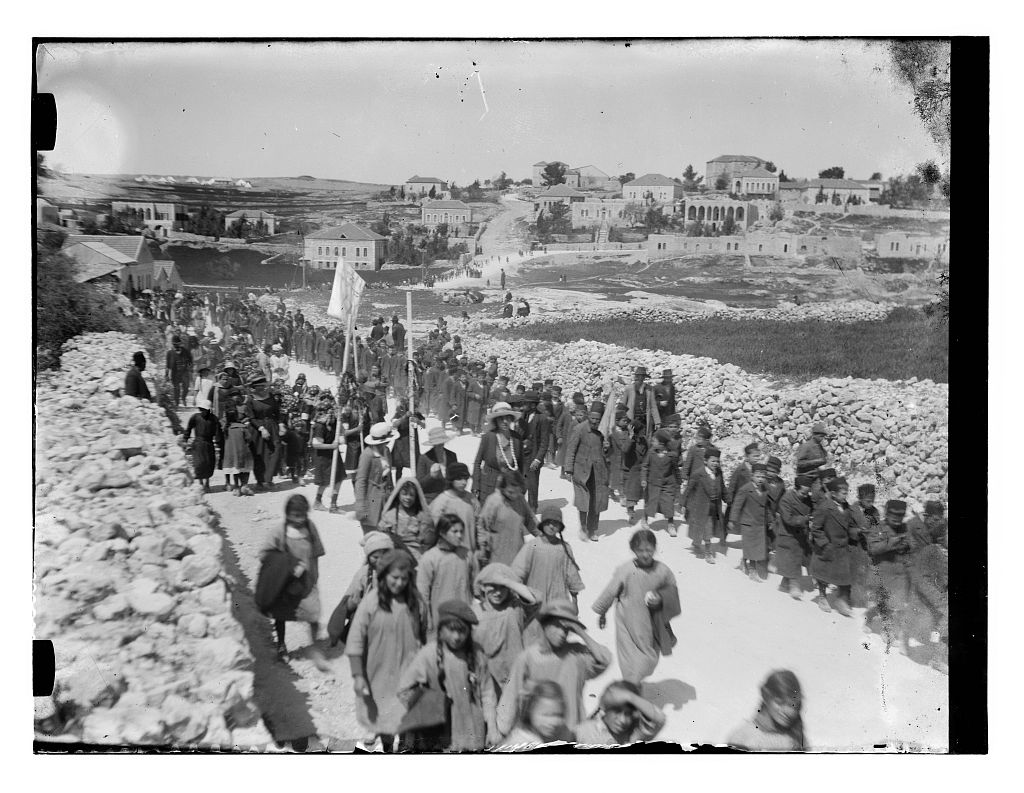
The American Colony's location adjacent to Nablus Road provided its photographers a vantage point on history. Picture 5 shows heavy British artillery being moved south on Nablus Road in 1917 or 1918. Picture 6 is a picture of Jewish children marching on Nablus Road in 1918. (An essay about the picture appears here.) Picture 7 shows British soldiers heading north responding to Arab riots in 1920.

7. British Soldiers heading north
past the mosque in response
to Arab rioting, 1920. Note the
Indian soldiers.

5. British artillery heading
south through Jerusalem
on Nablus Road. 1917-1918.
Note house with arches.
6. Jewish children marching south
on Nablus Road in 1918. Note
the house with the arches and
the British army camp on the
hill on the left. An essay about
this picture appears here
For comparison we also present an aerial photograph of Nablus Road in the 1930s and a contemporary picture of Nablus Road.

Aerial photograph of Nablus Road 1931. The house with
the arches had a second story added. Today it is a school.

Nablus Road today. Note the house
with the arches. The mosque complex is
on the right.


 |
| Revolt in prison, Damascus, circa 1895. Crowd of people outside of prison. |
We encourage experts on Syrian history to provide details on the events portrayed here.
0
Add a comment