10 Top-Rated Tourist Attractions in the Negev Region
The Negev Region is a desert adventurer's dream packed with ancient ruins and drop-dead gorgeous desert scenery. Wilderness lovers will adore the weird and wonderful panoramas from the top of Makhtesh Ramon as well as exploring this natural highlight by 4WD or hiking. While the extraordinary old Nabataean caravan towns and UNESCO World Heritage sites of Shivta, Avdat, and Mampsis offer a feast of interesting history. Ruggedly handsome, the Negev is a star attraction for anyone who appreciates natural beauty.
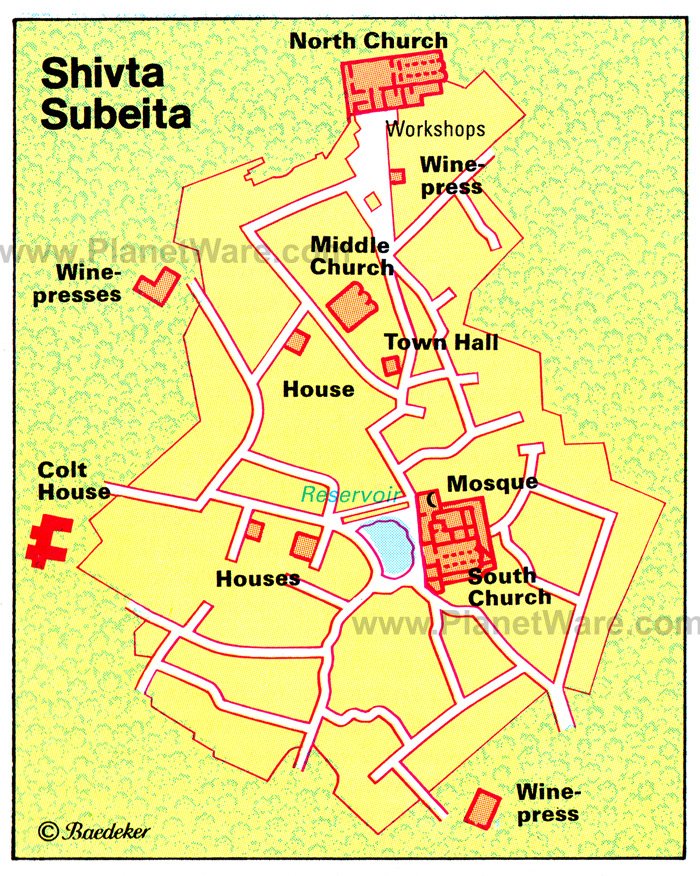
1 Shivta
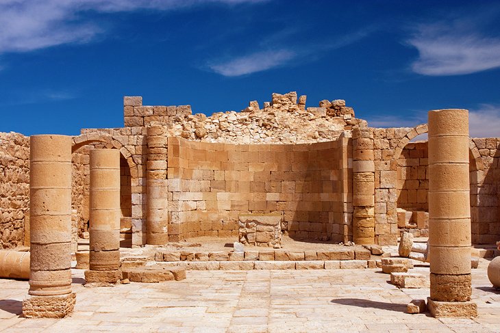
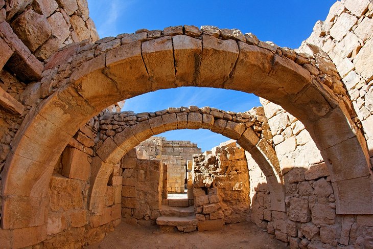
Shivta (ancient Subeita) is home to the astonishingly well-preserved ruins of a 5th and 6th-century Byzantine city with three monastic churches, dwellings, water cisterns, and paved streets all visible. It was first built and used by the Nabataeans during the 1st century BC and later rebuilt by the Byzantines. Although the ruins are all from this later stage, Shivta earns its UNESCO World Heritage Site-status from its earlier Nabataean habitation, as part of the Desert Cities Incense Route in the Negev. On entering the site, you first come to the three-aisled basilica of the South Church. Built against the church is a mosque dating from the 7th century. A little way north of the church is the Council House, which stands at the intersection of two streets. Taking the street to the left brings you to the Middle Churchof which only a few sections of wall and the south apse survive. Continuing north, you pass through the craftsmen's quarter, with pottery kiln, workshops, and baker's oven, before arriving at the North Church.
Location: 55 kilometers southwest of Be'er Sheva
2 Nizzana
Nizzana is another Nabataean town, which continued to exist in Byzantine and Arab times until the 9th century. Excavations here in 1935 brought to light churches and other buildings. One of the churches has a mosaic pavement. Near the Bedouin well of Auja el-Hafir, the Turks built a frontier post in 1907, and during the period of the Mandate the British authorities sited a prison camp here. In 1948, the Egyptian army used Nizzana as a base for an attack on Be'er Sheva.
Location: 17 kilometers southeast of Shivta
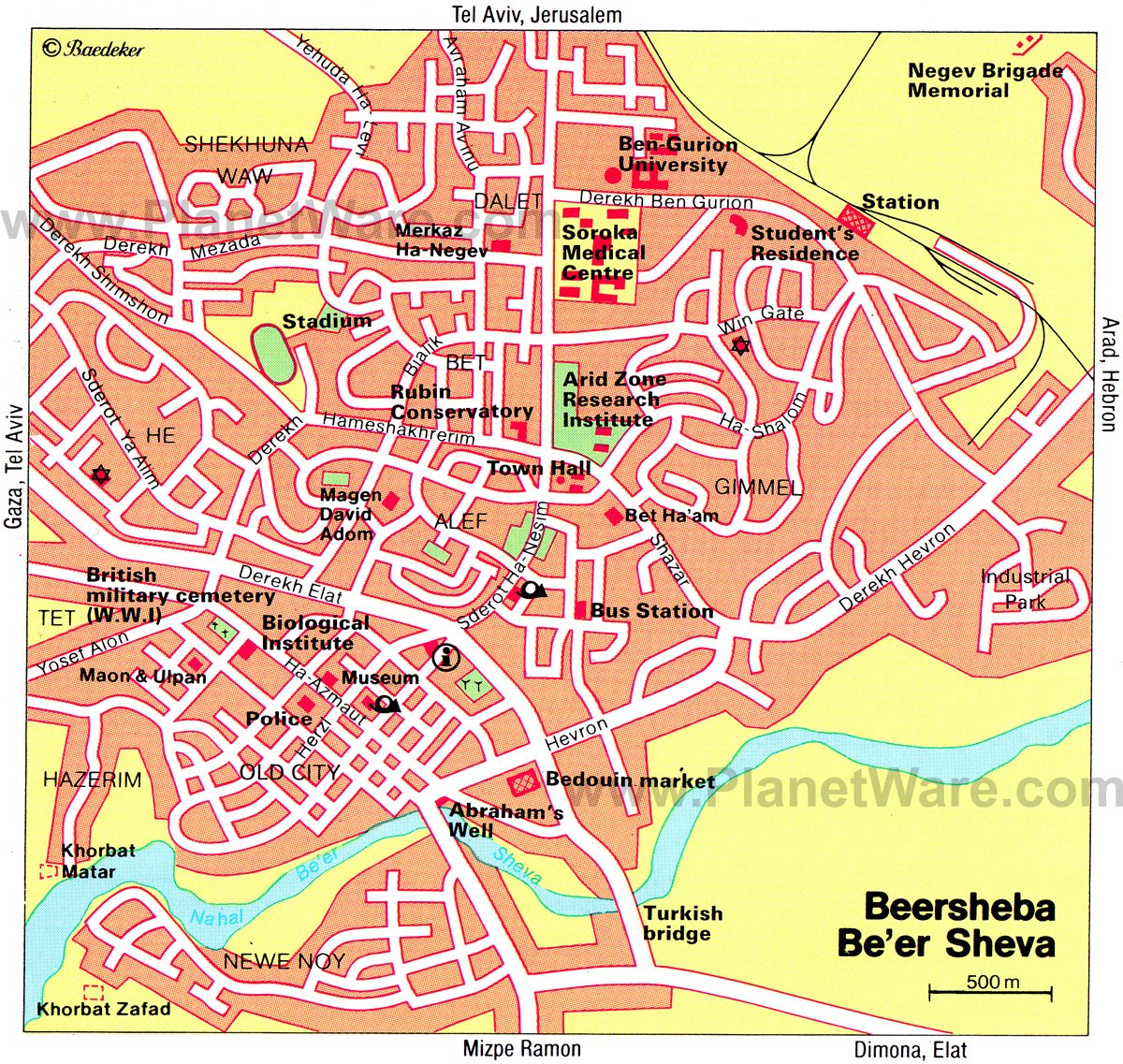
3 Be'er Sheva
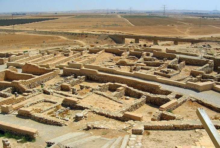
Famed in the Old Testament as the city of the Patriarchs, Be'er Sheva has developed within a few decades into the "capital of the Negev" and one of the largest cities in Israel. The earliest settlement in the area (Tel Sheva)lies on the eastern outskirts of the modern city. Excavation on the banks of the river has brought to light a Chalcolithic settlement of the 4th millennium BC occupied by semi-nomads, who constructed cisterns and underground dwellings entered from above. A number of finds from the site can be seen in the Israel Museum in Jerusalem. The main tourist attraction in town is the Thursday Bedouin Market (Eilat Road) where you can search out cushions, camel saddles, copperware, and numerous other craftwork. The Museum of Negev Art is on Ha'atzmaut Street, set in an Ottoman era building. At the southeast end of this street is a restored well, known as Abraham's Well (though it probably only dates from the Ottoman period). The main highlight of a visit to Be'er Sheva though is Tel Sheva, four kilometers northeast of the modern town. These are the remains of ancient Beersheba, and feature defensive walls and water channels.
4 Museum of Bedouin Culture
This museum, dedicated to Bedouin culture, has an intriguing ethnographic collection with exhibits of clothing, domestic equipment, jewelry, and various other everyday objects. The exhibits are well presented and provide an interesting introduction to the art and culture of the various Bedouin tribes of the Negev.
Location: Kibbutz Lahav, Joe Alon Centre, 20 kilometers northeast of Be'er Sheva
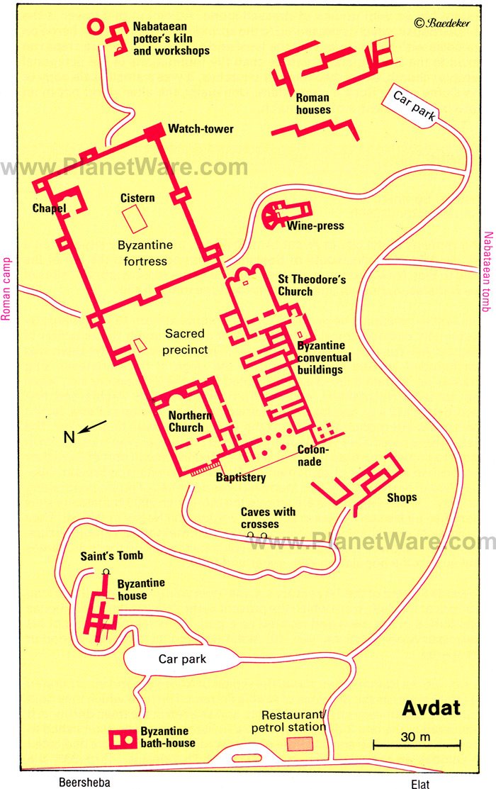
5 Avdat
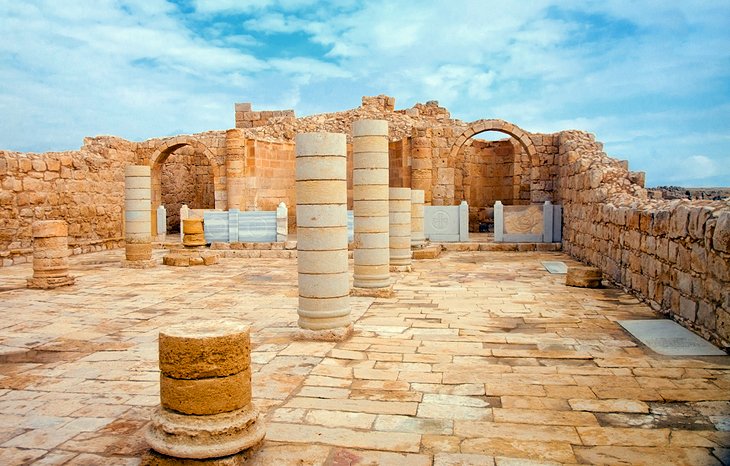
Prominently situated on a hill, the UNESCO World Heritage Site of Avdat(Avda in Arabic) is one of the most important sites of the Nabataean, Roman, and Byzantine periods in the Negev. It was first settled in the 3rd century BC when nomadic Nabataean tribes began to settle and take over the spice trade routes through the region. Later, the town thrived under Roman and then Byzantine occupation until finally being abandoned after the Arabs captured the town in AD 634. Just before the entry to the site proper, there is a Nabataean tomb with a doorway lintel relief depicting a horned altar flanked by the moon, sun, and a star. From the entry, a path leads north through a Roman era residential quarter where you can also see a stone bearing a Nabataean inscription. The path runs through the south gate into a rectangular Byzantine fortress. There is an excellent view over the entire site from the southeast corner here. Adjoining the western side of the fortress is a sacred precinct, which dates from the Byzantine period and contains two churches built on the sites of earlier Nabataean and Roman temples. Here, you find the Church of St. Theodore; a three-aisled basilica dedicated to a Greek martyr of the 4th century. Nearby, is the North Church with its preserved consoles supporting the roof beams in the southern aisle.
Location: 65 kilometers south of Be'er Sheva
6 En Avdat
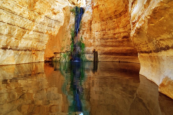
Near the Avdat ruins is one of the most surprising natural wonders of the Negev. The spring of En Avdat lies in the middle of a barren upland region of almost oppressive austerity. Here, four springs emerge from the rock, falling into a tranquil pool. Every morning and evening, the ibexes that live in the area come down to drink the water, so if you arrive at this time you can sneak some wilderness spotting into your itinerary as well.
Location: 65 kilometers south of Be'er Sheva
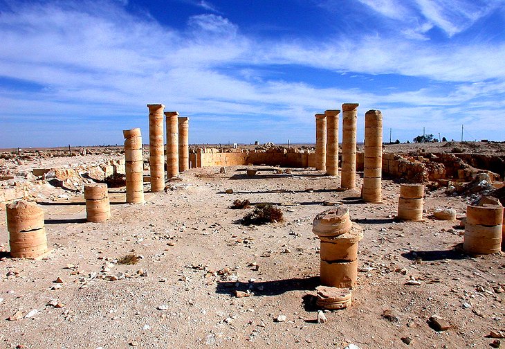
7 Mampsis
Ancient Mampsis (Hebrew "Mamshit", Arabic "Kurnub"), with its remarkable ruins, is the most northerly Nabataean town in the Negev and like Avdatand Shivta is a UNESCO World Heritage Site. Excavations between 1965 and 1973 brought to light a Nabataean settlement which had undergone little change in Byzantine times, so that its original character is better preserved than at Avdat, Nizzana, or Shivta. It was founded during the period when the Nabataeans, from their capital at Petra, set out to colonise the Negev. It prospered in the 1st century AD as a trading town with a caravanserai, stables, residential areas, and administrative buildings. After the fall of Nabataeans in AD 106, the Romans built barracks here. In Byzantine times (when Mampsis featured on the mosaic map at Madaba), the old Nabataean system of irrigation was brought into use again, as it was at Avdat, and two churches were built. The town was destroyed during the Arab conquest in the 7th century.
Entering through the north gate in the town walls, you continue along ancient streets between blocks of houses to two large administrative buildings. In one of the buildings, the arches have been preserved and it is possible to climb to the upper floor, from which there is a fine general view of the site. The West Church is built against the town walls. This aisled basilica was built by St. Nilus of Sinai in about AD 400. Immediately in front of the ruins of a police post from the British Mandate period, is the East Church, which was dedicated to the Holy Martyrs. It is approached by a broad flight of steps leading up from a square, which from Nabataean to Byzantine times was the market place. A mosaic pavement in the nave has been preserved. Other interesting buildings in Mampsis, identified by signs, include stables, a portico with Nabataean horn-capitals, and a building with well-preserved wall paintings.
To the west of the site, far below in the wadi, you can see the dams, which enabled the Nabataeans and Byzantines to store water during the short rainy season for use during the arid summer months.
Location: 42 kilometers southeast of Be'er Sheva
8 Sde Boker
The kibbutz of Sde Boker has close associations with David Ben-Gurion, Israel's first prime minister, who retired here. Ben-Gurion's House, with its interior largely unchanged since he died, can be visited and has a small, but interesting collection of photographs and letters. His and his wife's tomb, in a carefully tended cliff-top park, can also be visited. There are incredible views over the surrounding area from here.
Location: 50 kilometers south of Be'er Sheva
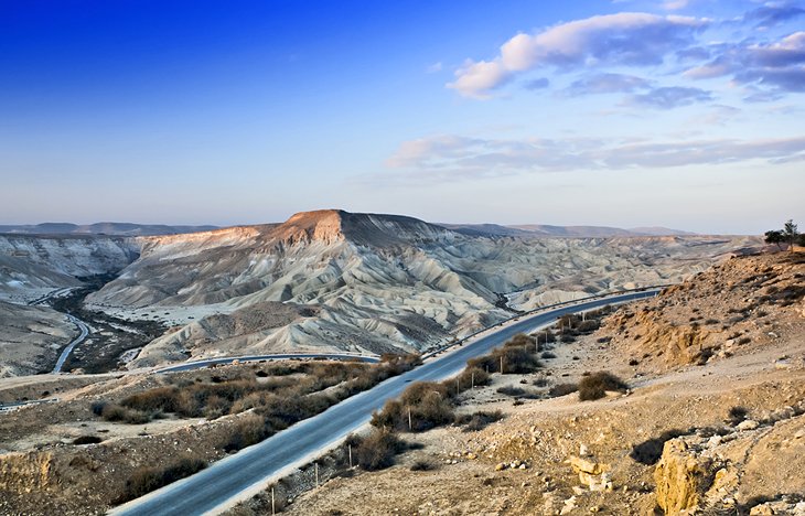
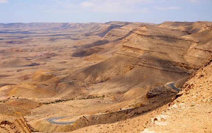
9 Makhtesh Ramon
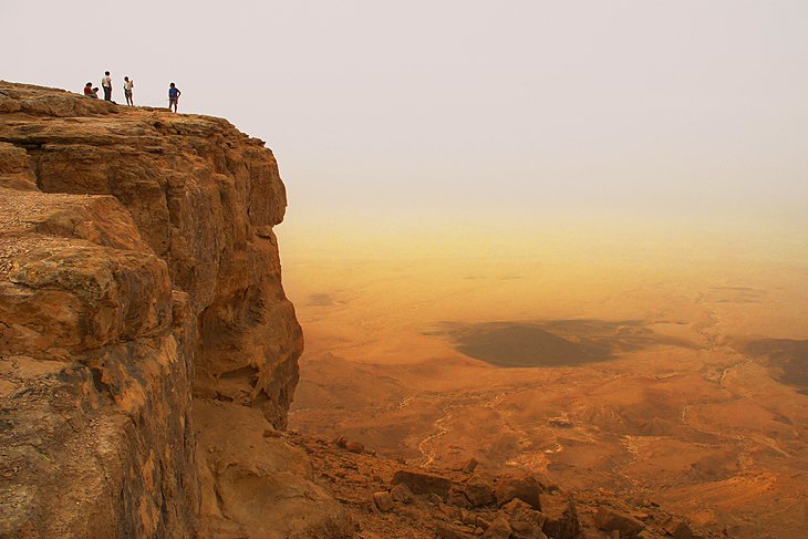
The largest of the three elliptical craters known as "mortars" (makhtesh) in the Negev is Makhtesh Ramon, which is 30 kilometers long by eight-kilometers wide. It is not a volcanic crater, but was formed 70 million years ago by the collapse of the land over underground cavities. Huge fossils of saurians, which lived 150 million years ago have been found here. The little town of Mitzpe Ramon has impressive views into the crater with the bottom 500 meters lower down.
On the east side are the remains of forts, notably Mezad Mishhor, built by the Nabataeans in the 1st century BC to protect the caravan route from their capital, Petra, to Avdat and via Subeita to Nizzana.
Location: 86 kilometers south of Be'er Sheva
10 Makhtesh Hagadol and Makhtesh HaQatan
Makhtesh Hagadol (the "Great Mortar") is the middle one of three erosion craters in the Negev, smaller than Makhtesh Ramon. Like Makhtesh HaQatan, the "Little Mortar", it lies to the north of the Wilderness of Zin. Both can be accessed via a hike. The best base is the town of Yeroham.
Location: 86 kilometers south of Be'er Sheva
History
The Negev seems to have become an arid area between 10,000 and 7,500 BC. In the 18th century BC, Abraham came from the north to Beersheba. In the later second millennium BC, the Negev was occupied by three peoples - to the north, around Arad, the Canaanites who had advanced farthest south; to the south, the Amalekites, whom David exterminated around 1,000 BC; to the east, around the Arava depression, the Edomites, who moved north in the sixth century BC, settled between Beersheba and Hebron, and became known as the Idumaeans.
From the first century BC, the Nabataeans sought to settle and cultivate the Negev from their capital at Petra. They achieved this with the help of ingenious methods of irrigation, and towns like Avdat, Subeita, and Mampsis were established. In the 4th-6th centuries the Byzantines took over from the Nabataeans and developed the region still further. After the arrival of the Arabs, who in other countries had improved irrigation methods, the irrigation systems of the Negev broke down, and for more than a thousand years, the Negev became an arid region inhabited by Bedouin.
The decisive impulse to make the land fertile again was given by David Ben-Gurion, a member of the kibbutz of Sde Boker, who established a university there for the study of the Negev. A scientific basis for the development of the region was provided by Michael Evenari, a botanist of German origin, who established a farm at Avdat using Nabataean methods and founded a plant research institute in Be'er Sheva. Of great importance for the resettlement of the Negev was the creation of the National Water Carrier, which brings water from northern Israel to the Negev.
No comments:
Post a Comment